Santorini: Volcanic Islands Cruise with Hot Springs Visit
10.869 reviews
Buy now
From 25,00€ per person
 Beach
Beach Village
 Attraction
 Island
 Airport
If you are planning your trip to Santorini, in the interactive map on this page you can find all the places of interest that we recommend you visit and other useful points of interest for your trip such as the airport. Simply click on the placeholders on the map, or in the list just below, to go to the in-depth tabs on the individual point of interest.
A must-have for every tourist, the Santorini tourist map is very useful for planning your itinerary to discover Santorini’s most beautiful beaches and must-see locations. Click on the thumbnail below to enlarge it and download and print it out.
Santorini is a volcanic island that was formed in prehistoric times. Thesemi-circular archipelago of Santorini is a complex of five islands, only two of which are inhabited, Thira and Thirassia, and is the result of hundreds of thousands of years of volcanic activity.
Santorini is part of the Cyclades archipelago of which, together with the small island of Anafi, it is the southernmost.
Santorini has 69 kilometres of coastline, not all of which is practicable due to the high and imposing cliffs of the caldera – the largest in the world and so completely filled with water that it also holds the record of being the only sunken caldera on the planet – that plunge 400 metres into the sea.
The island’s picturesque villages have been built on top of the gigantic lava walls, literally perched on the edge of the caldera, and face the sea, offering tourists a breathtaking panoramic view.
The islets of Palea Kameni, Mikra Kameni, Macronisi, Aspronisi and Nea Kameni were formed in more recent times following minor eruptions of the volcano.
Due to its volcanic origin, the island is characterised by a red-black colour and the beaches on the east coast, the most famous of which is Kamari, are of black pebbles.
 Hotel
Hotel  Budget accommodations
 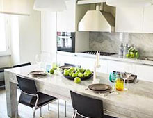 Apartments
  Family Hotel
  Luxury Hotel
  Resorts