Atlantis Hotel

Karpathos, the second largest island of the Dodecanese, represents a true hidden treasure of the southern Aegean. With its 324 square kilometres of predominantly mountainous terrain, the island offers a perfect balance of perfectly preserved millenary traditions and natural landscapes of extraordinary wild beauty.
Strategically located between Crete and Rhodes, Karpathos has managed to maintain a unique cultural identity, where ancient Doric customs still survive in villages that have remained unchanged over time. Its elongated shape and central mountain range, which reaches 1,215 metres with Mount Kali Limni, create a variety of microclimates and landscapes ranging from the fertile valleys of the south to the rugged cliffs of the north.
The island is famous for being a living ethnological museum, where it is possible to witness traditions that have disappeared for centuries elsewhere. Its authentic villages alternate with spectacular mountain landscapes, creating a unique travel experience on the Greek islands.
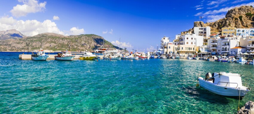
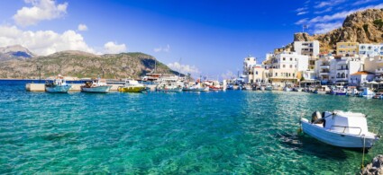
Pigadia, also known as Karpathos Town, is the lively capital of the island with over 3,000 inhabitants and is the main arrival point for sea and air. The town stretches along a natural bay in the south-eastern part of the island, offering a perfect blend of modern functionality and traditional charm.
The name Pigadia derives from ‘Ta Pigádia’ (‘The Fountains’), a reference to the numerous freshwater springs that fed the city and led to its development in 1892. The old town retains influences of Italian colonial architecture, a legacy of the 1912-1947 period when the island was part of the Italian Dodecanese.
The Archaeological Museum, housed in the Prefectural Palace, preserves important artefacts that testify to the island’s thousand-year history: Mycenaean ceramics, ancient coins, Roman statues and everyday objects that tell the story of the evolution of the Karpathian civilisation. The Pigadia promenade is the social heart of the town, with taverns serving fresh fish caught from local boats and traditional cafes.
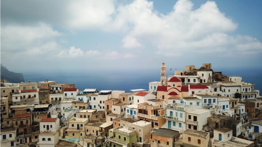
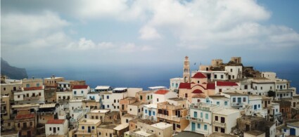
Olympos, perched 310 metres above sea level on the slopes of Mount Prophet Elias, represents one of the most extraordinary anthropological phenomena in contemporary Greece. This mountain village, founded in the 9th century A.D. to escape Saracen raids, has kept intact the traditions, dialect and customs of the ancient Doric civilisation.
The village is world-famous for being a ‘living museum’ where elderly women daily wear the traditional clothes handed down through generations: embroidered tunics, decorated aprons and elaborate headgear that exist nowhere else in the world. The spoken dialect preserves words from ancient Doric Greek, creating a linguistic bridge of over three thousand years.
The architecture of Olympos is characterised by colourful houses arranged amphitheatrically so as not to overshadow each other, each with its own windmill (there are about 75) and its own family church. The religious celebrations in Olympos, particularly those on 15 August (Assumption of the Virgin) and 6 August (Transfiguration), offer the opportunity to witness ancestral rituals with singing accompanied by lyre and laouto.
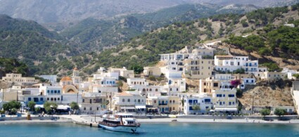
Arkasa, located on the west coast 23 km from Pigadia, is a picturesque fishing village with one of the most important archaeological sites on Karpathos. The modern village coexists harmoniously with the remains of ancient Arkesia, one of the four city-states of the ancient island.
The archaeological site of Paleokastro, situated on a promontory overlooking the sea, preserves the remains of anacropolis dating back to the classical Greek period. Excavations have unearthed ancient cisterns, Doric columns, temple foundations and beautiful mosaics with geometric and figurative motifs that testify to the importance of the city in antiquity.
The floor mosaic of the early Christian basilica of Agia Sophia, with its vivid colours still well preserved, represents one of the jewels of Byzantine art in the Greek islands. The strategic location of the site offers spectacular views of the island of Kasos and the sunsets that set the western sky ablaze.
Lefkos, located on the west coast about 35 km from Pigadia, is one of Karpathos’ most charming resorts, characterised by three wide bays separated by strips of land that overlook a sea of extraordinary turquoise colour. The village is divided into Ano Lefkos (the upper part) on the hillsides and Kato Lefkos, the modern settlement directly by the sea.
Once a simple fishing village with just a few houses, Lefkos has managed to retain a genuine flavour despite tourist development. Its family-run tavernas serve fresh fish and local specialities in an atmosphere of authentic tranquillity. The resort is perfect for families and couples seeking a totally relaxing holiday.
The area of Kato Lefkos conceals the remains of an ancient harbour town from the late Roman period, developed over three harbours and abandoned in the 7th century due to Saracen invasions. Today the resort offers studios and small accommodation, a small supermarket and a few tavernas, without the hustle and bustle of the more touristy centres.
Diafani, the island’s second port in the north, is a fishing village that has retained its authentic character. The name derives from the ‘diaphanous’ (transparent) quality of its crystal-clear waters, considered among the purest in the Aegean.
The small harbour is the starting point for excursions to the island of Saria, the nearby uninhabited island separated from Karpathos by only 100 metres of sea. Saria, part of the Natura 2000 project, is home to ruins of the ancient city of Nisyros and offers unspoilt beaches that can only be reached by sea.
The village retains its old-world atmosphere with family tavernas serving the catch of the day and specialities of Karpathian cuisine. In the evenings, the harbour comes alive with local social life, with fishermen repairing nets and preparing boats for night fishing. Diafani is connected to Olympos by a scenic road that offers unforgettable views of the northern coastline.
The island of Saria, separated from Karpathos by a channel only 100 metres wide, represents one of the last frontiers of wilderness in the Dodecanese. With its 45 inhabitants (2011 figures), mostly shepherds, this mountainous and rugged island is protected by the Natura 2000 programme for its extraordinary biodiversity.
Saria preserves the remains of the ancient city of Nisyros, founded in the Hellenistic period and abandoned during the Middle Ages due to pirate raids. Archaeological excavations have uncovered remains of temples, dwellings and a system of cisterns for collecting rainwater, bearing witness to a well-organised civilisation.
Saria’s flora and fauna are unique in the eastern Mediterranean: the island is home to endemic species of plants and is an important stopping point for migratory birds. Excursions to Saria depart from both Pigadia and Diafani during the summer months and include time for swimming, snorkelling and the exploration of archaeological sites.
Menetes, located inland in the south at an altitude of 350 metres, is famous for being the home of the Karpathian lyre, the traditional musical instrument that accompanies the island’s songs and dances. This picturesque mountain village has given birth to generations of lyre players and instrument makers.
The village perfectly preserves traditional Dodecanese architecture with local stone houses, flower-filled courtyards and cobbled streets winding between terraces planted with vines and olive trees. The colourful façades and ornate wooden balconies create a charming atmosphere, especially during sunset hours.
The Church of the Dormition of the Mother of God is the most important monument in the village and is considered the most beautiful church on Karpathos. The village keeps its handicraft traditions alive with workshops where traditional musical instruments, textiles and ceramics are still produced using ancient techniques.
Spoa, located at the narrowest point of the island at an altitude of about 300 metres, offers one of the most spectacular panoramic positions on Karpathos with simultaneous views of the eastern and western slopes. This small mountain village is an important road junction connecting the north and south of the island.
The village has retained its rural authenticity with traditional stone houses, cobbled alleys and a central square where old people gather in the cool hours of the day. The family-run Folia tavern, frequented by locals, serves mountain specialities prepared with local produce in an atmosphere of genuine Greek hospitality.
Spoa’s strategic location provides easy access to both the east and west coast beaches, making it an excellent stopping point during excursions. The road leading to the wild beaches of the north, such as Agios Minas and Agnontia, which are frequented by those seeking solitude and direct contact with nature, also departs from the village.
Mount Kali Limni, at an altitude of 1,215 metres, is the highest peak not only of Karpathos but of the entire Dodecanese archipelago. This imposing mountain, whose name means ‘Beautiful Lake’, dominates the central part of the island and offers breathtaking 360-degree views of the southern Aegean.
The hike to the summit requires physical preparation and adequate equipment, but rewards visitors with views that on a clear day extend as far as Crete, Rhodes and the Cyclades. The trail traverses a variety of ecosystems, from Mediterranean scrub to alpine rock formations, hosting a unique flora that includes endemic species of orchids and aromatic plants.
The mountain is of particular importance to the island’s microclimate: its slopes capture moisture from the sea winds, creating the conditions that feed the springs and make the Tragea Valley below fertile. During winter, the peak is often covered with snow, a rare sight on the Greek islands that underlines the geographical uniqueness of Karpathos.
In the following map you can see the location of the main places of interest mentioned in this article.
 Hotel
Hotel  Budget accommodations
  Apartments
  Family Hotel
  Luxury Hotel
  Resorts